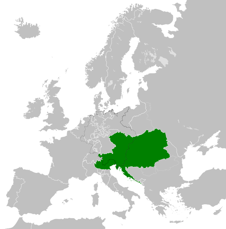
Файл:Austrian Empire (1815).svg

Size of this PNG preview of this SVG file: 450 × 456 пиксел. Башка уруксаттар: 237 × 240 пиксел | 474 × 480 пиксел | 758 × 768 пиксел | 1 011 × 1 024 пиксел | 2 021 × 2 048 пиксел.
Түп нуска файл (SVG файл, шарттуу түрдө 450 × 456 пиксел, файлдын өлчөмү: 691 KB)
Жыйынтыгы


.svg)
.svg)
.svg)
.svg)
.svg)


.svg)
.svg)
.svg)


.png)
.png)


.svg)


.svg)

.svg)


.svg)
.svg)
.svg)
.svg)


.svg)
.png)


.svg)


.svg)
.svg)


.svg)


.svg)


.svg)
.svg)
.svg)
.svg)
.svg)
.svg)
.svg)
.svg)
_cropped.svg)
.svg)
.svg)
.svg)
.svg)
.svg)
.svg)
.svg)
.svg)
.svg)
.svg)
.svg)
.svg)
.svg)
.svg)
.svg)
.svg)
.svg)
.svg)
.svg)
.svg)
.svg)
.svg)
.svg)
.svg)
.svg)
.svg)
.svg)
.svg)
.svg)
.svg)
.svg)
.svg)
.svg)
.svg)
.svg)
.svg)
.svg)
.svg)
.svg)
.svg)
.svg)
.svg)
.svg)
.svg)
.svg)
Файлдын тарыхы
Файлдын белгилүү бир учурдагы көрүнүшүн көрүү үчүн тийиштүү убакыт/датаны басыңыз
| Убакыт/дата | Миниатюра | Өлчөм | Колдонуучу | Түшүндүрмө | |
|---|---|---|---|---|---|
| учурдагы | 09:58, 16 апрель 2019 | | 450 × 456 (691 KB) | TRAJAN 117 | +++ |
| 21:20, 12 август 2013 |  | 450 × 456 (654 KB) | TRAJAN 117 | Update | |
| 05:47, 12 август 2013 |  | 450 × 456 (1 MB) | TRAJAN 117 | {{Information |Description ={{en|1=The Austrian Empire in 1815.}} |Source ={{own}} {{AttribSVG|Blank map of Europe 1815.svg|Alphathon}} |Author =TRAJAN 117 {{created with Inkscape}} |Date =2013-08-12 |Pe... |
Шилтемелер
Бул файл төмөнкү баракта колдонулат:
Файлдын глобалдык колдонулушу
Бул файл төмөнкү викилерде колдонулат:
- af.wikipedia.org сайтындагы колдонулушу
- ast.wikipedia.org сайтындагы колдонулушу
- azb.wikipedia.org сайтындагы колдонулушу
- ba.wikipedia.org сайтындагы колдонулушу
- bg.wikipedia.org сайтындагы колдонулушу
- br.wikipedia.org сайтындагы колдонулушу
- ce.wikipedia.org сайтындагы колдонулушу
- cs.wikipedia.org сайтындагы колдонулушу
- cy.wikipedia.org сайтындагы колдонулушу
- de.wikipedia.org сайтындагы колдонулушу
- el.wikipedia.org сайтындагы колдонулушу
- en.wikipedia.org сайтындагы колдонулушу
- es.wikipedia.org сайтындагы колдонулушу
- fi.wikipedia.org сайтындагы колдонулушу
- frr.wikipedia.org сайтындагы колдонулушу
- fr.wikipedia.org сайтындагы колдонулушу
- ga.wikipedia.org сайтындагы колдонулушу
- gd.wikipedia.org сайтындагы колдонулушу
- gl.wikipedia.org сайтындагы колдонулушу
- he.wikipedia.org сайтындагы колдонулушу
- hi.wikipedia.org сайтындагы колдонулушу
- hr.wikipedia.org сайтындагы колдонулушу
- hy.wikipedia.org сайтындагы колдонулушу
- id.wikipedia.org сайтындагы колдонулушу
- id.wikibooks.org сайтындагы колдонулушу
- incubator.wikimedia.org сайтындагы колдонулушу
- is.wikipedia.org сайтындагы колдонулушу
- it.wikipedia.org сайтындагы колдонулушу
- jam.wikipedia.org сайтындагы колдонулушу
- ja.wikipedia.org сайтындагы колдонулушу
- ka.wikipedia.org сайтындагы колдонулушу
- km.wikipedia.org сайтындагы колдонулушу
- ko.wikipedia.org сайтындагы колдонулушу
- lmo.wikipedia.org сайтындагы колдонулушу
- lt.wikipedia.org сайтындагы колдонулушу
- lv.wikipedia.org сайтындагы колдонулушу
- mk.wikipedia.org сайтындагы колдонулушу
- mn.wikipedia.org сайтындагы колдонулушу
- nap.wikipedia.org сайтындагы колдонулушу
- nl.wikipedia.org сайтындагы колдонулушу
- pa.wikipedia.org сайтындагы колдонулушу
Бул файлдын глобалдык колдонулушун көрүү.
.svg)
.svg)