Асыл нуска файлы(1 000 × 1 000 пиксель, файлдын көлөмү: 215 KB, MIME түрү: image/jpeg)

Бул файл Викиказына долбоорунан. Ошондой эле башка долбоорлордо пайдаланылышы мүмкүн. Төмөндө файлды сыпаттоо барагындагы сыпаттамасы көрсөтүлгөн.

Жыйынтыгы

Сыпаттама
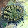
English: Satellite image of the Brandberg Massif, Namibia. Original figure caption: “Brandberg Massif is a dome-shaped granite intrusion that covers 250 square miles (650 square kilometers) and rises 1.6 miles (2,573 meters) above its surroundings in the central Namib Desert. Brandberg Massif is an important habitat for high-altitude savannah species and is of great archaeological interest due to the many prehistoric cave paintings found among its granite cliffs.
Deutsch: Satellitenbild des Brandberg Massivs, Namibia. Original Bildbeschriftung (modifizierte Übersetzung): Das Brandbergmassiv ist eine kuppelförmige Granit-Intrusion, deren Ausbiss sich über 650 Quadratkilometer erstreckt und sich 2.573 Meter über sein Umland in der zentralen Namib-Wüste erhebt. Das Brandberg-Massiv ist ein wichtiger Lebensraum für Pflanzen- und Tierarten der Hochlandsavanne und von hohem archäologischem Interesse aufgrund der zahlreichen frühgeschichtlichen Höhlenmalereien in seinen Granitklippen.
Дата 10 сентябрь 2002 (“acquisition date”)
Булак http://landsat.usgs.gov/images/gallery/26_L.jpg
Автор USGS

Лицензиялоо

Public domain
This image is in the public domain in the United States because it only contains materials that originally came from the United States Geological Survey, an agency of the United States Department of the Interior. For more information, see the official USGS copyright policy.

Bahasa Indonesia  català  čeština  Deutsch  eesti  English  español  français  galego  italiano  Nederlands  português  polski  sicilianu  suomi  Tiếng Việt  Türkçe  български  македонски  русский  മലയാളം  한국어  日本語  中文  中文(简体)  中文(繁體)  العربية  فارسی  +/−

Captions

Add a one-line explanation of what this file represents

Items portrayed in this file

depicts англисче

10 сентябрь 2002

MIME type англисче

image/jpeg

checksum англисче

14cdf2233bc91a9172ec853bb25bd2890573a295

determination method англисче: SHA-1 англисче

data size англисче

220169 Байт

height англисче

1000 пиксель

width англисче

1000 пиксель

Файлдын тарыхы

Файлдын белгилүү бир учурдагы көрүнүшүн көрүү үчүн тийиштүү убакыт/датаны басыңыз

Убакыт/датаМиниатюраӨлчөмКолдонуучуТүшүндүрмө
учурдагы23:41, 23 август 200523:41, 23 август 2005 -дагы версиясы үчүн кичирейтилген сүрөтү1 000 × 1 000 (215 KB)Atamari{{PD-USGov-USGS}} * Brandberg Massif, Namibia * Acquisition Date:Sep 10,2002 * source http://landsat.usgs.gov/gallery/detail/367/ category:Namibia

Бул файл төмөнкү баракта колдонулат:

Файлдын глобалдык колдонулушу

Бул файл төмөнкү викилерде колдонулат:

Метамаалымат