Файл:Dagestan topographic map-ru.svg

Size of this PNG preview of this SVG file: 400 × 512 пиксел. Башка уруксаттар: 187 × 240 пиксел | 375 × 480 пиксел | 600 × 768 пиксел | 800 × 1 024 пиксел | 1 600 × 2 048 пиксел.
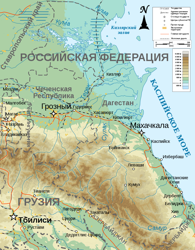
Түп нуска файл (SVG файл, шарттуу түрдө 400 × 512 пиксел, файлдын өлчөмү: 2,79 MB)
Жыйынтыгы
| Сыпаттама |
[] |
| Дата | |
| Булак |
English: Own work ; Topographic data from the NASA Shuttle Radar Topography Mission (SRTM3 v.2) (public domain) edited with 3DEM, reprojected in UTM with GDAL (GDAL), and vectorized with Inkscape ; UTM projection ; WGS84 datum ; shaded relief (composite image of N-W, W and N lightning positions) ; Reference used for the additional data : * Rivers, cities, railroads, routes, bathymetry : Demis add-on for World Wind (see the approval e-mail and the Demis forum) ; * Borders and coast : World data bank II ; Approximate scale of topographic data : 1:1,463,000 ; Note : The shaded relief is a raster image embedded in the SVG file. Français : Création personnelle ; Données topographiques de la NASA Shuttle Radar Topography Mission (SRTM3 v.2) (domaine public) éditées avec 3DEM, reprojetées en UTM avec GDAL et vectorisées avec Inkscape ; projection UTM ; WGS84 datum ; relief ombré (image composite d'éclairages du N-O, O et N) ; Références utilisées pour les données complémentaires : * Rivières, villes, chemins de fers, routes, bathymétrie : Demis add-on for World Wind (cf. l'e-mail d'approbation de Demis et le Demis forum) ; * Frontières et côtes : World data bank II ; Échelle approximative des données topographiques : 1:1 463 000 ; Note : Le relief ombré est une image bitmap embarquée dans le fichier SVG. |
| Автор | Bourrichon - fr:Bourrichon |
| Уруксат (Бул файл кайрадан колдонууда) |
GFDL / Attribution and Share-Alike required |
| Башка нускалар |
[]
|


|
This SVG file contains embedded text that can be translated into your language, using any capable SVG editor, text editor or the SVG Translate tool. For more information see: About translating SVG files. |
Лицензиялоо
I, the copyright holder of this work, hereby publish it under the following licenses:

|
Permission is granted to copy, distribute and/or modify this document under the terms of the GNU Free Documentation License, Version 1.2 or any later version published by the Free Software Foundation; with no Invariant Sections, no Front-Cover Texts, and no Back-Cover Texts. A copy of the license is included in the section entitled GNU Free Documentation License. |
This file is licensed under the Creative Commons Attribution-Share Alike 4.0 International, 3.0 Unported, 2.5 Generic, 2.0 Generic and 1.0 Generic license.
- Сиз буларга эркинсиз:
- бөлүшүү – чыгарманы көчүрүү, жайылтуу жана өткөрүп берүү
- ремикс кылуу – чыгарманы ылайыкташтыруу
- Төмөнкү шарттарда:
- атрибуция – Сиз тийиштүү насыя берип, лицензияга шилтеме калтырып жана өзгөртүүлөр болсо көрсөтүшүңүз керек. Сиз муну кандайдыр бир акылга сыярлык жол менен жасай аласыз, бирок лицензиар сизди же сиздин колдонууңузду жактырган кандайдыр бир жол менен эмес.
- Бирдей шарттар боюнча бөлүшүү – If you remix, transform, or build upon the material, you must distribute your contributions under the same or compatible license as the original.
Сиз тандаган лицензияны тандай аласыз.
Original upload log
This image is a derivative work of the following images:
- File:Dagestan_topographic_map-fr.svg licensed with Cc-by-sa-3.0,2.5,2.0,1.0, GFDL
- 2008-11-13T16:57:44Z Bourrichon 400x512 (3429307 Bytes) retrait bathy inutile
- 2008-11-09T17:23:11Z Bourrichon 400x512 (3434618 Bytes)
- 2008-11-08T16:24:23Z Bourrichon 400x512 (3433344 Bytes) == Summary == {{Information |Description={{de|Topographische Karte von [[:de:Kaukasien|Kaukasien]], französische Version}}{{en|Topographic map in French of [[:en:Caucasus|Caucasus]]}}{{fr|Carte topographique en français du
Uploaded with derivativeFX
Файлдын тарыхы
Файлдын белгилүү бир учурдагы көрүнүшүн көрүү үчүн тийиштүү убакыт/датаны басыңыз
| Убакыт/дата | Миниатюра | Өлчөм | Колдонуучу | Түшүндүрмө | |
|---|---|---|---|---|---|
| учурдагы | 23:35, 11 май 2019 | | 400 × 512 (2,79 MB) | Takhirgeran Umar | . |
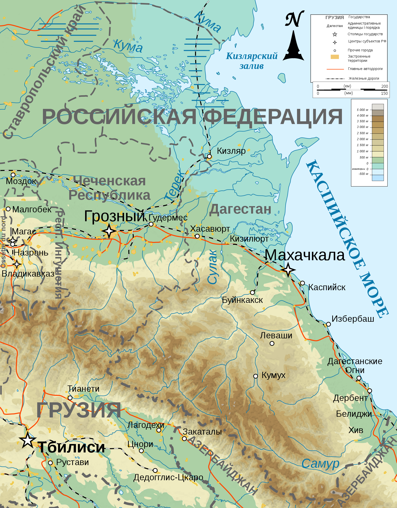
| 15:05, 6 март 2010 |  | 400 × 512 (2,79 MB) | S.L. | better version, some mistakes fixed | |
| 15:00, 6 март 2010 |  | 400 × 512 (2,79 MB) | S.L. | {{Information |Description={{Information |Description={{{en|Topographic map in Russian of Dagestan}} |Source={{en|Own work ;<br/>Topographic data from the [http://www2.jpl.nasa.gov/srtm NASA Shuttle Radar Topography Mission] (SRTM3 v.2) ( |
Шилтемелер
Бул файлды колдонгон барактар жок.
Файлдын глобалдык колдонулушу
Бул файл төмөнкү викилерде колдонулат:
- av.wikipedia.org сайтындагы колдонулушу
- az.wikipedia.org сайтындагы колдонулушу
- ba.wikipedia.org сайтындагы колдонулушу
- ceb.wikipedia.org сайтындагы колдонулушу
- fr.wikipedia.org сайтындагы колдонулушу
- it.wikipedia.org сайтындагы колдонулушу
- kbd.wikipedia.org сайтындагы колдонулушу
- kk.wikipedia.org сайтындагы колдонулушу
- ru.wikipedia.org сайтындагы колдонулушу
- sr.wikipedia.org сайтындагы колдонулушу
- www.wikidata.org сайтындагы колдонулушу