Файл:Guiana shield map-fr.svg

Size of this PNG preview of this SVG file: 742 × 599 пиксел. Башка уруксаттар: 297 × 240 пиксел | 594 × 480 пиксел | 951 × 768 пиксел | 1 268 × 1 024 пиксел | 2 535 × 2 048 пиксел | 3 123 × 2 523 пиксел.
Асыл нуска файлы (SVG файл, шарттуу түрдө 3 123 × 2 523 пиксел, файлдын өлчөмү: 1,03 MB)
Жыйынтыгы
| Сыпаттама |
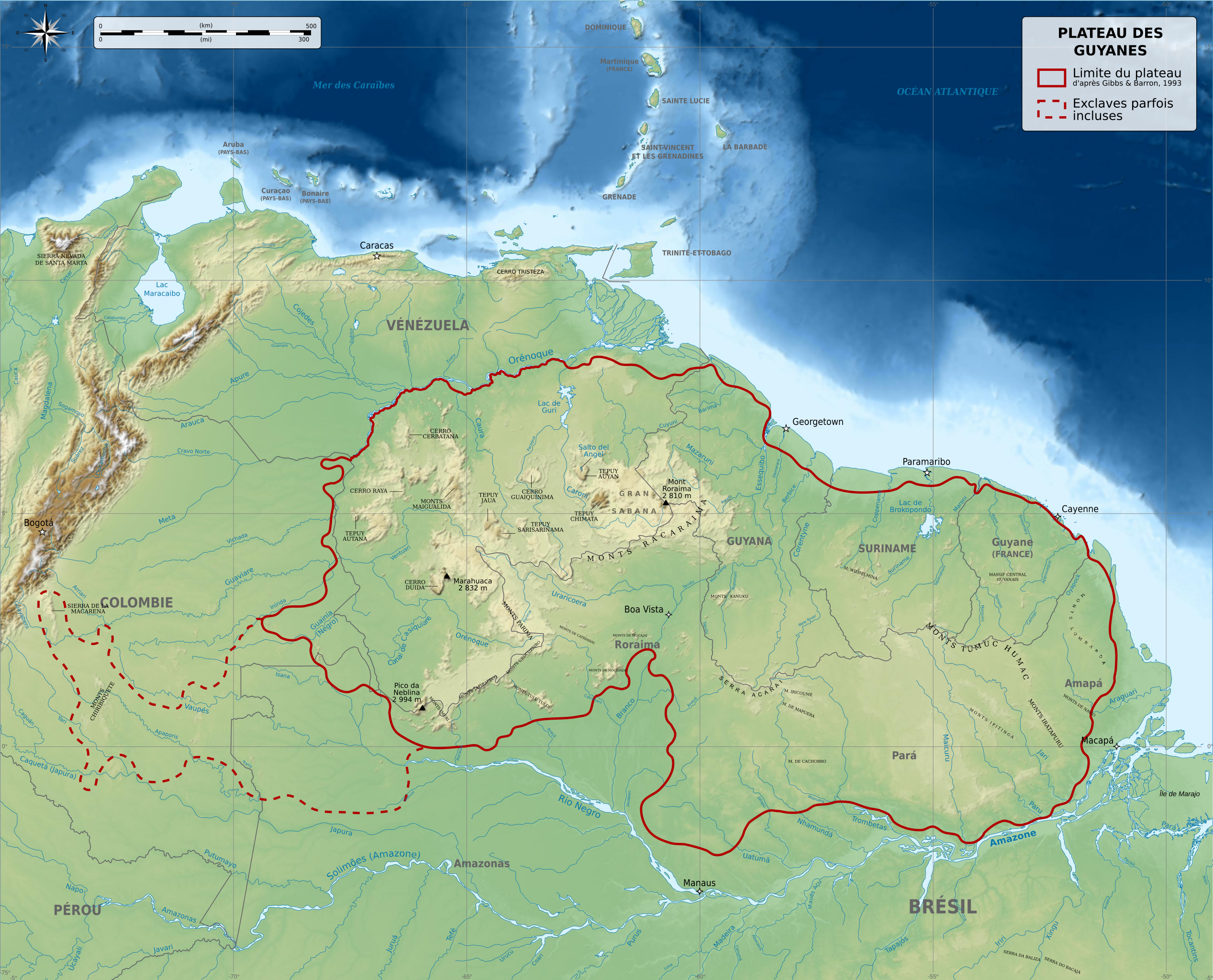
English: Physical map of Guiana Shield, a craton located in South America, between Brazil, French Guiana, Suriname, Guyana, Venezuela and Colombia. Français : Carte physique du plateau des Guyanes, un craton situé en Amérique du Sud, répartis entre le Brésil, la Guyane française, le Suriname, le Guyana, le Vénézuela et la Colombie. Македонски: Карта на Гвајанскиот Штит во Јужна Америка. |
||
| Дата | |||
| Булак |
Жумушубуз. Source :
Additional data :
|
||
| Автор | Sémhur (talk) | ||
| Башка нускалар |
Derivative works of this file: | ||
| Атрибуция (required by the license) | © Sémhur / Wikimedia Commons / | ||
| SVG | W3C-validity not checked.
|
||
| Graphic Lab |


-es.svg)
-es.svg)
| Camera location | | View this and other nearby images on: OpenStreetMap |
|---|
Лицензиялоо
I, the copyright holder of this work, hereby publish it under the following licenses:
| Copyleft: This work of art is free; you can redistribute it and/or modify it according to terms of the Free Art License. You will find a specimen of this license on the Copyleft Attitude site as well as on other sites. |
This file is licensed under the Creative Commons Attribution-Share Alike 4.0 International, 3.0 Unported, 2.5 Generic, 2.0 Generic and 1.0 Generic license.
- Сиз буларга эркинсиз:
- бөлүшүү – чыгарманы көчүрүү, жайылтуу жана өткөрүп берүү
- ремикс кылуу – чыгарманы ылайыкташтыруу
- Төмөнкү шарттарда:
- атрибуция – Сиз тийиштүү насыя берип, лицензияга шилтеме калтырып жана өзгөртүүлөр болсо көрсөтүшүңүз керек. Сиз муну кандайдыр бир акылга сыярлык жол менен жасай аласыз, бирок лицензиар сизди же сиздин колдонууңузду жактырган кандайдыр бир жол менен эмес.
- Бирдей шарттар боюнча бөлүшүү – If you remix, transform, or build upon the material, you must distribute your contributions under the same or compatible license as the original.
Сиз тандаган лицензияны тандай аласыз.
Файлдын тарыхы
Файлдын белгилүү бир учурдагы көрүнүшүн көрүү үчүн тийиштүү убакыт/датаны басыңыз
| Убакыт/дата | Миниатюра | Өлчөм | Колдонуучу | Түшүндүрмө | |
|---|---|---|---|---|---|
| учурдагы | 06:49, 27 май 2014 | | 3 123 × 2 523 (1,03 MB) | Sémhur | Valid SVG |
| 21:53, 5 декабрь 2010 |  | 3 123 × 2 523 (1,03 MB) | Sémhur | Mispelling : Mer ces Caraïbes => Mer des Caraïbes | |
| 18:57, 3 декабрь 2010 |  | 3 123 × 2 523 (1,03 MB) | Sémhur | With the good size | |
| 18:55, 3 декабрь 2010 |  | 512 × 414 (1,08 MB) | Sémhur | == {{int:filedesc}} == {{Information |Description={{Multilingual description |en= Physical map of Guiana Shield, a craton located in South America, between Brazil, French Guiana, Suriname, Guyana, Venezuela and Colombi |
Шилтемелер
Бул файл төмөнкү баракта колдонулат:
Файлдын глобалдык колдонулушу
Бул файл төмөнкү викилерде колдонулат:
- es.wikipedia.org сайтындагы колдонулушу
- fr.wikipedia.org сайтындагы колдонулушу
- gcr.wikipedia.org сайтындагы колдонулушу
- it.wikipedia.org сайтындагы колдонулушу
- mn.wikipedia.org сайтындагы колдонулушу
- nl.wikipedia.org сайтындагы колдонулушу
- oc.wiktionary.org сайтындагы колдонулушу