Файл:New Caledonia and Vanuatu bathymetric and topographic map-fr.jpg

Алдын ала көрүүнүн көлөмү: 800 × 561 пиксел Башка уруксаттар: 320 × 224 пиксел | 640 × 449 пиксел | 1 024 × 718 пиксел | 1 280 × 898 пиксел | 2 560 × 1 795 пиксел | 2 980 × 2 090 пиксел.
Асыл нуска файлы (2 980 × 2 090 пиксель, файлдын көлөмү: 1,53 MB, MIME түрү: image/jpeg)
Жыйынтыгы
| Сыпаттама |
|
||
| Дата | ; revision 2013-12 | ||
| Булак |
Own work ;
|
||
| Автор | Eric Gaba (Sting - fr:Sting) | ||
| Уруксат (Бул файл кайрадан колдонууда) |
|
||
| Башка нускалар |
[]
Administrative and simplified version:
|


| Camera location | | View this and other nearby images on: OpenStreetMap |
|---|
Лицензиялоо
I, the copyright holder of this work, hereby publish it under the following licenses:

|
Permission is granted to copy, distribute and/or modify this document under the terms of the GNU Free Documentation License, Version 1.2 or any later version published by the Free Software Foundation; with no Invariant Sections, no Front-Cover Texts, and no Back-Cover Texts. A copy of the license is included in the section entitled GNU Free Documentation License. |
This file is licensed under the Creative Commons Attribution-Share Alike 4.0 International, 3.0 Unported, 2.5 Generic, 2.0 Generic and 1.0 Generic license.
- Сиз буларга эркинсиз:
- бөлүшүү – чыгарманы көчүрүү, жайылтуу жана өткөрүп берүү
- ремикс кылуу – чыгарманы ылайыкташтыруу
- Төмөнкү шарттарда:
- атрибуция – Сиз тийиштүү насыя берип, лицензияга шилтеме калтырып жана өзгөртүүлөр болсо көрсөтүшүңүз керек. Сиз муну кандайдыр бир акылга сыярлык жол менен жасай аласыз, бирок лицензиар сизди же сиздин колдонууңузду жактырган кандайдыр бир жол менен эмес.
- Бирдей шарттар боюнча бөлүшүү – If you remix, transform, or build upon the material, you must distribute your contributions under the same or compatible license as the original.
Сиз тандаган лицензияны тандай аласыз.
Файлдын тарыхы
Файлдын белгилүү бир учурдагы көрүнүшүн көрүү үчүн тийиштүү убакыт/датаны басыңыз
| Убакыт/дата | Миниатюра | Өлчөм | Колдонуучу | Түшүндүрмө | |
|---|---|---|---|---|---|
| учурдагы | 17:40, 19 декабрь 2013 | | 2 980 × 2 090 (1,53 MB) | Sting | Île de Sable removed (cf http://www.shom.fr/fileadmin/data-www/DMI/Communiques_de_presse/2012/COMMUNIQUE-DE-PRESSE-SANDY-ISLAND.doc) ; new elevation data used (SRTM30 Plus) |
| 11:38, 30 май 2011 |  | 2 980 × 2 090 (1,46 MB) | Sting | Reverted to version as of 21:32, 16 July 2010 (sRGB profile) | |
| 20:40, 17 июль 2010 |  | 2 980 × 2 090 (1,35 MB) | Sting | Better unsaturated colors than over-saturated ones in non color managed browsers | |
| 21:32, 16 июль 2010 |  | 2 980 × 2 090 (1,46 MB) | Sting | Color profile correction | |
| 23:05, 29 июнь 2010 |  | 2 980 × 2 090 (1,35 MB) | Sting | With sRGB color profile | |
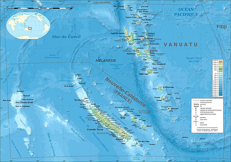
| 03:12, 17 февраль 2009 |  | 2 980 × 2 090 (1,39 MB) | Sting | == Summary == {{Location|18|30|00|S|166|00|00|E|scale:10000000}} <br/> {{Information |Description={{en|Bathymetric and topographic map of New Caledonia and Vanuatu, Oceania.}} {{fr|Carte bathymétrique |
Шилтемелер
Бул файл төмөнкү баракта колдонулат:
Файлдын глобалдык колдонулушу
Бул файл төмөнкү викилерде колдонулат:
- avk.wikipedia.org сайтындагы колдонулушу
- azb.wikipedia.org сайтындагы колдонулушу
- bg.wikipedia.org сайтындагы колдонулушу
- bi.wikipedia.org сайтындагы колдонулушу
- bs.wikinews.org сайтындагы колдонулушу
- en.wikipedia.org сайтындагы колдонулушу
- eo.wikipedia.org сайтындагы колдонулушу
- es.wikipedia.org сайтындагы колдонулушу
- fi.wikipedia.org сайтындагы колдонулушу
- fr.wikipedia.org сайтындагы колдонулушу
- Vanuatu
- Liste des colonies françaises
- Christian Zuber
- Nouvelle-Calédonie
- Référendum en France
- Projet:Cartographie/Cartes standards/Pays
- 2010 par pays en Océanie
- 2011 par pays en Océanie
- Rallye de Nouvelle-Calédonie
- Français océanien
- Utilisateur:Exp JC/Brouillon
- Environnement en Nouvelle-Calédonie
- 2010 en Nouvelle-Calédonie
- 2011 au Vanuatu
- 2010 au Vanuatu
- fr.wikinews.org сайтындагы колдонулушу
- fr.wikiversity.org сайтындагы колдонулушу
- gcr.wikipedia.org сайтындагы колдонулушу
- gl.wikipedia.org сайтындагы колдонулушу
- he.wikipedia.org сайтындагы колдонулушу
- hu.wikipedia.org сайтындагы колдонулушу
- la.wikipedia.org сайтындагы колдонулушу
- lfn.wikipedia.org сайтындагы колдонулушу
- nl.wikipedia.org сайтындагы колдонулушу
- nn.wikipedia.org сайтындагы колдонулушу
- oc.wikipedia.org сайтындагы колдонулушу
- pl.wikipedia.org сайтындагы колдонулушу
- pl.wikivoyage.org сайтындагы колдонулушу
- pt.wikipedia.org сайтындагы колдонулушу
Бул файлдын глобалдык колдонулушун көрүү.