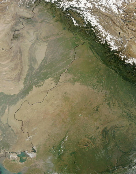
Файл:Thar Desert satellite.jpg

Алдын ала көрүүнүн көлөмү: 471 × 599 пиксел Башка уруксаттар: 189 × 240 пиксел | 500 × 636 пиксел.
Түп нуска файл (500 × 636 пиксель, файлдын көлөмү: 329 KB, MIME түрү: image/jpeg)
Файлдын тарыхы
Файлдын белгилүү бир учурдагы көрүнүшүн көрүү үчүн тийиштүү убакыт/датаны басыңыз
| Убакыт/дата | Миниатюра | Өлчөм | Колдонуучу | Түшүндүрмө | |
|---|---|---|---|---|---|
| учурдагы | 14:25, 17 сентябрь 2005 |  | 500 × 636 (329 KB) | Crux | Satellite Image of Thar Desert, India/Pakistan (border line in the middle) from en:, uploaded by en:User:Tom Radulovich |
Шилтемелер
Бул файл төмөнкү баракта колдонулат:
Файлдын глобалдык колдонулушу
Бул файл төмөнкү викилерде колдонулат:
- ar.wikipedia.org сайтындагы колдонулушу
- az.wikipedia.org сайтындагы колдонулушу
- bg.wikipedia.org сайтындагы колдонулушу
- bn.wikipedia.org сайтындагы колдонулушу
- bs.wikipedia.org сайтындагы колдонулушу
- ckb.wikipedia.org сайтындагы колдонулушу
- de.wikipedia.org сайтындагы колдонулушу
- en.wikipedia.org сайтындагы колдонулушу
- eo.wikipedia.org сайтындагы колдонулушу
- es.wikipedia.org сайтындагы колдонулушу
- et.wikipedia.org сайтындагы колдонулушу
- fa.wikipedia.org сайтындагы колдонулушу
- fi.wikipedia.org сайтындагы колдонулушу
- fr.wikipedia.org сайтындагы колдонулушу
- he.wikipedia.org сайтындагы колдонулушу
- hu.wikipedia.org сайтындагы колдонулушу
- it.wikipedia.org сайтындагы колдонулушу
- ja.wikipedia.org сайтындагы колдонулушу
- ka.wikipedia.org сайтындагы колдонулушу
- kk.wikipedia.org сайтындагы колдонулушу
- kn.wikipedia.org сайтындагы колдонулушу
- ko.wikipedia.org сайтындагы колдонулушу
- lfn.wikipedia.org сайтындагы колдонулушу
- lt.wikipedia.org сайтындагы колдонулушу
- mai.wikipedia.org сайтындагы колдонулушу
- mg.wikipedia.org сайтындагы колдонулушу
- mk.wikipedia.org сайтындагы колдонулушу
- ml.wikipedia.org сайтындагы колдонулушу
- mr.wikipedia.org сайтындагы колдонулушу
- ms.wikipedia.org сайтындагы колдонулушу
- ne.wikipedia.org сайтындагы колдонулушу
- nn.wikipedia.org сайтындагы колдонулушу
- pa.wikipedia.org сайтындагы колдонулушу
- pl.wikipedia.org сайтындагы колдонулушу
- pnb.wikipedia.org сайтындагы колдонулушу
- pt.wikipedia.org сайтындагы колдонулушу
Бул файлдын глобалдык колдонулушун көрүү.

