Файл:Topographic map of Åland.svg

Size of this PNG preview of this SVG file: 681 × 516 пиксел. Башка уруксаттар: 317 × 240 пиксел | 634 × 480 пиксел | 1 014 × 768 пиксел | 1 280 × 970 пиксел | 2 560 × 1 940 пиксел.
Түп нуска файл (SVG файл, шарттуу түрдө 681 × 516 пиксел, файлдын өлчөмү: 172 KB)
Жыйынтыгы
This W3C-unspecified vector image was created with Inkscape .
| Сыпаттама |
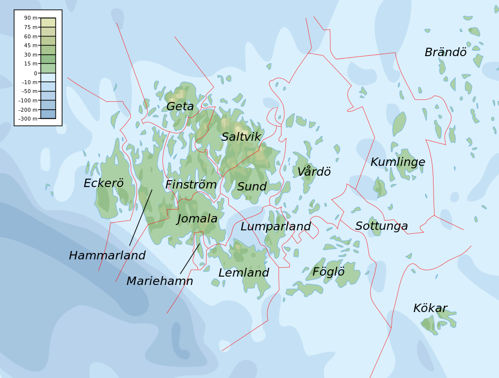
English: Topographic map of the Åland Islands.
Français : Carte topographique des îles d'Åland.
Suomi: Ahvenanmaan topografinen kartta.
Approximate limits:
|
| Дата | |
| Булак |
Self-made in Inkscape. Boundaries and municipality borders based on Image:Alandmunicipalities.png. Topography based on public domain GLOBE data from NOAA (http://www.ngdc.noaa.gov/mgg/topo/gltiles.html). Bathymetry adapted after a small slice from T. Seifert, F. Tauber, B. Kayser: 2001: "A high resolution spherical grid topography of the Baltic Sea – 2nd edition", Baltic Sea Science Congress, Stockholm 25-29. November 2001, Poster #147, www.io-warnemuende.de/iowtopo. Colors and overall look based on maps by User:Bamse. |
| Автор | Mysid |
| Башка нускалар | Derivative works of this file: Aland EU.svg |

|
This SVG file contains embedded text that can be translated into your language, using any capable SVG editor, text editor or the SVG Translate tool. For more information see: About translating SVG files. |
Лицензиялоо
I, the copyright holder of this work, hereby publish it under the following licenses:

|
Permission is granted to copy, distribute and/or modify this document under the terms of the GNU Free Documentation License, Version 1.2 or any later version published by the Free Software Foundation; with no Invariant Sections, no Front-Cover Texts, and no Back-Cover Texts. A copy of the license is included in the section entitled GNU Free Documentation License. |
This file is licensed under the Creative Commons Attribution-Share Alike 4.0 International, 3.0 Unported, 2.5 Generic, 2.0 Generic and 1.0 Generic license.
- Сиз буларга эркинсиз:
- бөлүшүү – чыгарманы көчүрүү, жайылтуу жана өткөрүп берүү
- ремикс кылуу – чыгарманы ылайыкташтыруу
- Төмөнкү шарттарда:
- атрибуция – Сиз тийиштүү насыя берип, лицензияга шилтеме калтырып жана өзгөртүүлөр болсо көрсөтүшүңүз керек. Сиз муну кандайдыр бир акылга сыярлык жол менен жасай аласыз, бирок лицензиар сизди же сиздин колдонууңузду жактырган кандайдыр бир жол менен эмес.
- Бирдей шарттар боюнча бөлүшүү – If you remix, transform, or build upon the material, you must distribute your contributions under the same or compatible license as the original.
Сиз тандаган лицензияны тандай аласыз.
Файлдын тарыхы
Файлдын белгилүү бир учурдагы көрүнүшүн көрүү үчүн тийиштүү убакыт/датаны басыңыз
| Убакыт/дата | Миниатюра | Өлчөм | Колдонуучу | Түшүндүрмө | |
|---|---|---|---|---|---|
| учурдагы | 11:06, 12 февраль 2008 | | 681 × 516 (172 KB) | Mysid | border wouldn't work |
| 11:05, 12 февраль 2008 |  | 681 × 516 (172 KB) | Mysid | {{inkscape}} {{Information |Description={{en|Topographic map of the Åland Islands.}} {{fi|Ahvenanmaan topografinen kartta.}} |Source=Self-made in Inkscape.<br/>Boundaries and municipality borders based on [[:Imag |
Шилтемелер
Бул файл төмөнкү баракта колдонулат:
Файлдын глобалдык колдонулушу
Бул файл төмөнкү викилерде колдонулат:
- ar.wikipedia.org сайтындагы колдонулушу
- az.wiktionary.org сайтындагы колдонулушу
- ba.wikipedia.org сайтындагы колдонулушу
- be.wikipedia.org сайтындагы колдонулушу
- bs.wikipedia.org сайтындагы колдонулушу
- de.wikipedia.org сайтындагы колдонулушу
- en.wikipedia.org сайтындагы колдонулушу
- et.wikipedia.org сайтындагы колдонулушу
- fi.wikipedia.org сайтындагы колдонулушу
- fo.wikipedia.org сайтындагы колдонулушу
- fr.wikipedia.org сайтындагы колдонулушу
- fy.wikipedia.org сайтындагы колдонулушу
- gd.wikipedia.org сайтындагы колдонулушу
- he.wikipedia.org сайтындагы колдонулушу
- is.wikipedia.org сайтындагы колдонулушу
- kk.wikipedia.org сайтындагы колдонулушу
- lb.wikipedia.org сайтындагы колдонулушу
- mi.wikipedia.org сайтындагы колдонулушу
- no.wikipedia.org сайтындагы колдонулушу
- os.wikipedia.org сайтындагы колдонулушу
- rue.wikipedia.org сайтындагы колдонулушу
- ru.wikipedia.org сайтындагы колдонулушу
- simple.wiktionary.org сайтындагы колдонулушу
- sv.wikipedia.org сайтындагы колдонулушу
- uk.wikipedia.org сайтындагы колдонулушу
- zh.wikipedia.org сайтындагы колдонулушу