Файл:Tunguska-Map-fr.svg

Size of this PNG preview of this SVG file: 800 × 409 пиксел. Башка уруксаттар: 320 × 164 пиксел | 640 × 328 пиксел | 1 024 × 524 пиксел | 1 280 × 655 пиксел | 2 560 × 1 310 пиксел | 977 × 500 пиксел.
Асыл нуска файлы (SVG файл, шарттуу түрдө 977 × 500 пиксел, файлдын өлчөмү: 235 KB)
Жыйынтыгы
| Сыпаттама |
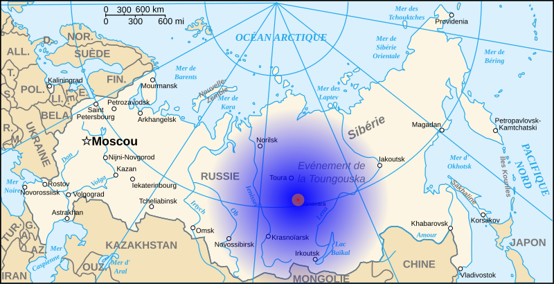
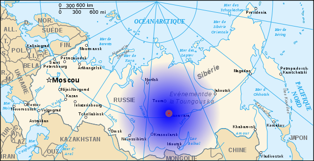
Français : Situation et zones d'impact de la météorite de la Toungouska.
Zone 1 (R=20 km) : forêt détruite (rouge) Zone 2 (R=100 km) : dégâts, brûlures, morts d'animaux (orange) Zone 3 (R=1500 km) : bruit de l'explosion (dégradé bleu) |
| Дата | |
| Булак | travail personnel (own work) à partir de Image:Map of Russia-fr.svg |
| Автор | Denys (fr) ; historicair |
This W3C-unspecified vector image was created with Inkscape .

|
Ce fichier SVG contient du texte encapsulé pouvant facilement être traduit dans votre langue en utilisant n'importe quel éditeur de fichier SVG ou de texte, ou par l'outil de traduction de fichiers SVG. Pour plus d'informations, voir : A propos de la traduction des fichiers SVG. |
Лицензиялоо
I, the copyright holder of this work, hereby publish it under the following licenses:

|
Permission is granted to copy, distribute and/or modify this document under the terms of the GNU Free Documentation License, Version 1.2 or any later version published by the Free Software Foundation; with no Invariant Sections, no Front-Cover Texts, and no Back-Cover Texts. A copy of the license is included in the section entitled GNU Free Documentation License. |
This file is licensed under the Creative Commons Attribution 3.0 Unported license.
- Сиз буларга эркинсиз:
- бөлүшүү – чыгарманы көчүрүү, жайылтуу жана өткөрүп берүү
- ремикс кылуу – чыгарманы ылайыкташтыруу
- Төмөнкү шарттарда:
- атрибуция – Сиз тийиштүү насыя берип, лицензияга шилтеме калтырып жана өзгөртүүлөр болсо көрсөтүшүңүз керек. Сиз муну кандайдыр бир акылга сыярлык жол менен жасай аласыз, бирок лицензиар сизди же сиздин колдонууңузду жактырган кандайдыр бир жол менен эмес.
Сиз тандаган лицензияны тандай аласыз.
Файлдын тарыхы
Файлдын белгилүү бир учурдагы көрүнүшүн көрүү үчүн тийиштүү убакыт/датаны басыңыз
| Убакыт/дата | Миниатюра | Өлчөм | Колдонуучу | Түшүндүрмө | |
|---|---|---|---|---|---|
| учурдагы | 08:31, 1 июль 2008 | | 977 × 500 (235 KB) | Denys | {{Information |Description={{fr|1=Situation et zones d'impact de la météorite de la Toungaska. Zone 1 (R=20 km) : forêt détruite (rouge) Zone 2 (R=100 km) : dégâts, brûlures, morts d'animaux (orange) Zone 3 (R=1500 km) : bruit de l'explosion (dégr |
Шилтемелер
Бул файл төмөнкү баракта колдонулат:
Файлдын глобалдык колдонулушу
Бул файл төмөнкү викилерде колдонулат:
- az.wikipedia.org сайтындагы колдонулушу
- bg.wikipedia.org сайтындагы колдонулушу
- ca.wikipedia.org сайтындагы колдонулушу
- en.wikipedia.org сайтындагы колдонулушу
- eu.wikipedia.org сайтындагы колдонулушу
- fr.wikipedia.org сайтындагы колдонулушу
- Événement de la Toungouska
- Discussion:Événement de la Toungouska
- Utilisateur:Denys/Schemas
- Utilisateur:Andrej Boris Collinsson/Images Sibérie 2
- Wikipédia:Le Bistro/30 juin 2016
- Wikipédia:Le Bistro/Galerie/2016
- Wikipédia:Le Bistro/Galerie/Juin
- Wikipédia:Statistiques des anecdotes de la page d'accueil/Visibilité des anecdotes (2020)
- Discussion:Événement de la Toungouska/LSV 17672
- Wikipédia:Statistiques des anecdotes de la page d'accueil/Visibilité des anecdotes (2020)/2020 02
- Projet:Aide et accueil/Twitter/Tweets/archives/février 2020
- Wikipédia:Le saviez-vous ?/Archives/2020
- ga.wikipedia.org сайтындагы колдонулушу
- he.wikipedia.org сайтындагы колдонулушу
- hr.wikipedia.org сайтындагы колдонулушу
- hu.wikipedia.org сайтындагы колдонулушу
- hy.wikipedia.org сайтындагы колдонулушу
- it.wikipedia.org сайтындагы колдонулушу
- it.wikiquote.org сайтындагы колдонулушу
- no.wikipedia.org сайтындагы колдонулушу
- oc.wikipedia.org сайтындагы колдонулушу
- pl.wikipedia.org сайтындагы колдонулушу
- ro.wikipedia.org сайтындагы колдонулушу
- sr.wikipedia.org сайтындагы колдонулушу
- ta.wikipedia.org сайтындагы колдонулушу
- tr.wikipedia.org сайтындагы колдонулушу
- vec.wikipedia.org сайтындагы колдонулушу
- www.wikidata.org сайтындагы колдонулушу