Файл:Guyane map-fr.svg

Size of this PNG preview of this SVG file: 497 × 600 пиксел. Башка уруксаттар: 199 × 240 пиксел | 398 × 480 пиксел | 637 × 768 пиксел | 849 × 1 024 пиксел | 1 698 × 2 048 пиксел | 1 183 × 1 427 пиксел.
Түп нуска файл (SVG файл, шарттуу түрдө 1 183 × 1 427 пиксел, файлдын өлчөмү: 907 KB)
Жыйынтыгы
| Сыпаттама |
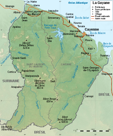
English: Map of French Guiana.
Français : Carte de la Guyane.
|
||
| Дата | |||
| Булак |
|
||
| Автор | Sémhur | ||
| Башка нускалар |
[] SVG
| ||
| Атрибуция (required by the license) | © Sémhur / Wikimedia Commons / | ||
| SVG | W3C-validity not checked.
|
||
| Graphic Lab |


| Camera location | | View this and other nearby images on: OpenStreetMap |
|---|
Лицензиялоо
I, the copyright holder of this work, hereby publish it under the following licenses:
| Copyleft: This work of art is free; you can redistribute it and/or modify it according to terms of the Free Art License. You will find a specimen of this license on the Copyleft Attitude site as well as on other sites. |
This file is licensed under the Creative Commons Attribution-Share Alike 4.0 International, 3.0 Unported, 2.5 Generic, 2.0 Generic and 1.0 Generic license.
- Сиз буларга эркинсиз:
- бөлүшүү – чыгарманы көчүрүү, жайылтуу жана өткөрүп берүү
- ремикс кылуу – чыгарманы ылайыкташтыруу
- Төмөнкү шарттарда:
- атрибуция – Сиз тийиштүү насыя берип, лицензияга шилтеме калтырып жана өзгөртүүлөр болсо көрсөтүшүңүз керек. Сиз муну кандайдыр бир акылга сыярлык жол менен жасай аласыз, бирок лицензиар сизди же сиздин колдонууңузду жактырган кандайдыр бир жол менен эмес.
- Бирдей шарттар боюнча бөлүшүү – If you remix, transform, or build upon the material, you must distribute your contributions under the same or compatible license as the original.
Каалаган лицензияны тандай аласыз.
Файлдын тарыхы
Файлдын мурдагы нускасын көрүү үчүн тийиштүү убакыт/датаны басыңыз
| Убакыт/дата | Миниатюра | Өлчөм | Колдонуучу | Түшүндүрмө | |
|---|---|---|---|---|---|
| учурдагы | 21:10, 29 июль 2017 | | 1 183 × 1 427 (907 KB) | Triton | correction Dekou Dekou |
| 15:44, 28 январь 2009 |  | 1 183 × 1 427 (907 KB) | Sémhur | Correcting two labels | |
| 15:10, 28 январь 2009 |  | 1 183 × 1 427 (907 KB) | Sémhur | {{Information |Description={{en|1=Map of French Guiana.}} {{fr|1=Carte de la Guyane.}} |Source=travail personnel (own work). Sources : * File:Guyane department relief location map.jpg by {{u|Sting}} under licence |
Шилтемелер
Бул файлды колдонгон барактар жок.
Файлдын глобалдык колдонулушу
Бул файл төмөнкү викилерде колдонулат:
- ar.wikipedia.org сайтындагы колдонулушу
- arz.wikipedia.org сайтындагы колдонулушу
- de.wikipedia.org сайтындагы колдонулушу
- es.wikipedia.org сайтындагы колдонулушу
- fr.wikipedia.org сайтындагы колдонулушу
- Liste de fleuves de France
- Guyane
- Discussion:Guyane
- Région ultrapériphérique
- Réseau routier de la Guyane
- Géographie de la Guyane
- Utilisateur:Elapied
- Massif du Mitaraka
- Discussion:Maripasoula
- Wikipédia:Atelier graphique/Cartes/Archives/janvier 2009
- Projet:Cartographie/Cartes standards/France
- Jean-Louis Loubère
- Patrimoine juif des départements, régions et territoires d’Outre-Mer
- Tampok
- Ouaqui
- Utilisateur:Peperwhite
- Utilisateur:Exp JC/Brouillon
- fr.wikinews.org сайтындагы колдонулушу
- fr.wikiversity.org сайтындагы колдонулушу
- gcr.wikipedia.org сайтындагы колдонулушу
- it.wikipedia.org сайтындагы колдонулушу
- mg.wikipedia.org сайтындагы колдонулушу
- nl.wikipedia.org сайтындагы колдонулушу
- pcd.wikipedia.org сайтындагы колдонулушу
- pl.wikipedia.org сайтындагы колдонулушу
- ro.wikipedia.org сайтындагы колдонулушу
- sco.wikipedia.org сайтындагы колдонулушу
- stq.wikipedia.org сайтындагы колдонулушу
- to.wikipedia.org сайтындагы колдонулушу
- www.wikidata.org сайтындагы колдонулушу