Файл:Hohle Linde Obermarbach Ostansicht.JPG

Учурда көрсөтүлүүчү өлчөм: 449 × 599 пиксел Башка уруксаттар: 180 × 240 пиксел | 359 × 480 пиксел | 708 × 945 пиксел.
Түп нуска файл (708 × 945 пиксель, файлдын өлчөмү: 164 KB, MIME түрү: image/jpeg)
Жыйынтыгы
| Сыпаттама |
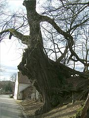
Deutsch: Die Hohle Linde in Obermarbach, Ostansicht |
| Дата | |
| Булак | Self-photographed |
| Автор | Nasenbär |
| Camera location | | View this and other nearby images on: OpenStreetMap |
|---|
Лицензиялоо
Nasenbär from de.wikipedia.org, the copyright holder of this work, hereby publishes it under the following license:

|
Permission is granted to copy, distribute and/or modify this document under the terms of the GNU Free Documentation License, Version 1.2 or any later version published by the Free Software Foundation; with no Invariant Sections, no Front-Cover Texts, and no Back-Cover Texts. A copy of the license is included in the section entitled GNU Free Documentation License. |
| This file is licensed under the Creative Commons Attribution-Share Alike 3.0 Unported license. | ||
| Атрибуция: Nasenbär | ||
| ||
| This licensing tag was added to this file as part of the GFDL licensing update. |
Das Photo der Linde zeigt weiter unten das Haus der "Bauernschmiede" von Franz Stemmer!
Original upload log
Transferred from de.wikipedia to Commons.
The original description page was here. All following user names refer to de.wikipedia.
- 2008-01-20 19:44 Nasenbär 708×945 (168056 bytes) {{Information |Beschreibung = Die Hohle in Obermarbach, Ostansicht |Quelle = selbst fotografiert |Urheber =~~~ |Datum = 19.01.2008 |Genehmigung = |Andere Versionen = |Anmerkungen = }}
Файлдын тарыхы
Файлдын мурдагы нускасын көрүү үчүн тийиштүү убакыт/датаны басыңыз
| Убакыт/дата | Миниатюра | Өлчөм | Колдонуучу | Түшүндүрмө | |
|---|---|---|---|---|---|
| учурдагы | 16:45, 10 январь 2009 | | 708 × 945 (164 KB) | Sarkana | {{Information |Description={{de|Die Hohle in Obermarbach, Ostansicht}} |Source=Transferred from [http://de.wikipedia.org de.wikipedia]<br/> (Original text : ''selbst fotografiert'') |Date=2008-01-20 (original upload date)<br/> (Original text : ''19.01.200 |
Шилтемелер
Бул файл төмөнкү баракта колдонулат:
Файлдын глобалдык колдонулушу
Бул файл төмөнкү викилерде колдонулат:
- ceb.wikipedia.org сайтындагы колдонулушу
- ce.wikipedia.org сайтындагы колдонулушу
- da.wikipedia.org сайтындагы колдонулушу
- de.wikipedia.org сайтындагы колдонулушу
- es.wikipedia.org сайтындагы колдонулушу
- eu.wikipedia.org сайтындагы колдонулушу
- fr.wikipedia.org сайтындагы колдонулушу
- hu.wikipedia.org сайтындагы колдонулушу
- hy.wikipedia.org сайтындагы колдонулушу
- it.wikipedia.org сайтындагы колдонулушу
- ku.wikipedia.org сайтындагы колдонулушу
- lld.wikipedia.org сайтындагы колдонулушу
- lmo.wikipedia.org сайтындагы колдонулушу
- pl.wikipedia.org сайтындагы колдонулушу
- pt.wikipedia.org сайтындагы колдонулушу
- ro.wikipedia.org сайтындагы колдонулушу
- ru.wikipedia.org сайтындагы колдонулушу
- sr.wikipedia.org сайтындагы колдонулушу
- tt.wikipedia.org сайтындагы колдонулушу
- uk.wikipedia.org сайтындагы колдонулушу
- uz.wikipedia.org сайтындагы колдонулушу
- vi.wikipedia.org сайтындагы колдонулушу
- www.wikidata.org сайтындагы колдонулушу