Файл:Map of traditional provinces of Libye-en.svg

Size of this PNG preview of this SVG file: 625 × 599 пиксел. Башка уруксаттар: 250 × 240 пиксел | 501 × 480 пиксел | 801 × 768 пиксел | 1 068 × 1 024 пиксел | 2 136 × 2 048 пиксел | 969 × 929 пиксел.
Түп нуска файл (SVG файл, шарттуу түрдө 969 × 929 пиксел, файлдын өлчөмү: 106 KB)
| Сыпаттама |
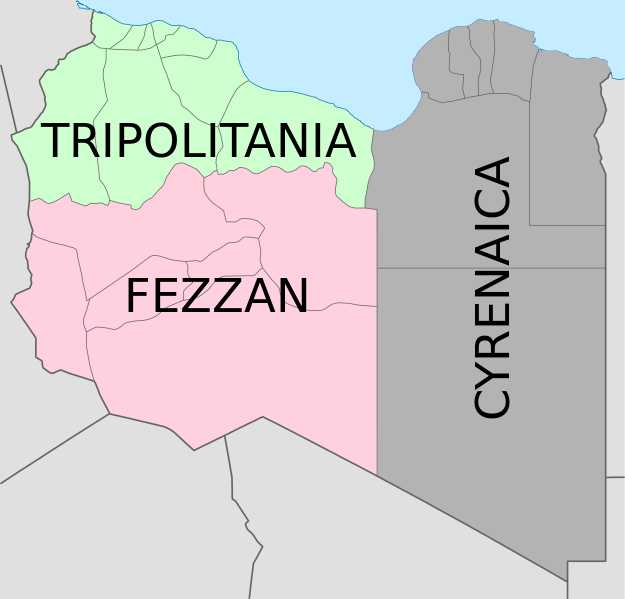
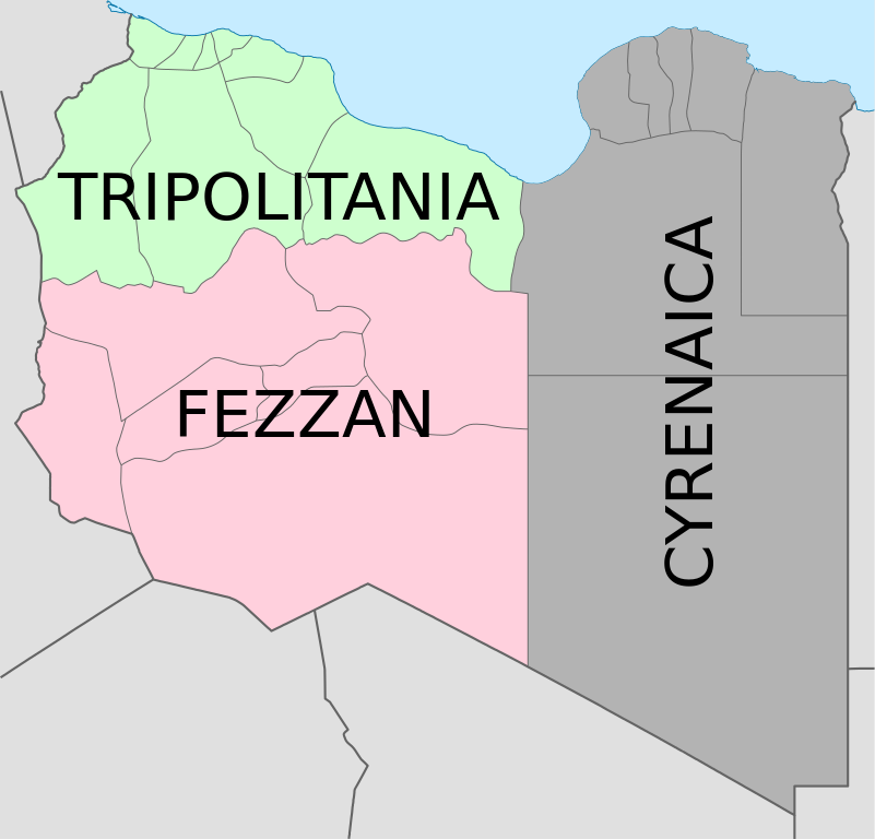
Deutsch: Historische provinzen (Governorates) Libyens English: Map of the three Governorates of Libya based on the borders of today's governorates. After independence in 1951, until 1963, Libya was divided into three governorates (muhafazat): Cyrenaica, Tripolitania, and Fezzan. The eastern border between Tripolitania and Fezzan was before 1969 slightly different: the northern part of Al Jufrah District in today's Fezzan belonged to Tripolitania, see here File:Ottoman Provinces Of Present day Libyapng.png. Español: Mapa de las tres governorates de Libia: Tripolitania, Fezzan, y Cirenaica. Français : Carte en anglais des trois provinces historiques (gouvernorats) de la Libye contemporaine. |
| Дата | (UTC) |
| Булак | |
| Автор |
|
| Башка нускалар |
|


| This is a retouched picture, which means that it has been digitally altered from its original version. Modifications: translation in english. The original can be viewed here: Map of traditionnal provinces of Libye fr.svg:
|
I, the copyright holder of this work, hereby publish it under the following licenses:
This file is licensed under the Creative Commons Attribution 3.0 Unported license.
- Сиз буларга эркинсиз:
- бөлүшүү – чыгарманы көчүрүү, жайылтуу жана өткөрүп берүү
- ремикс кылуу – чыгарманы ылайыкташтыруу
- Төмөнкү шарттарда:
- атрибуция – Сиз тийиштүү насыя берип, лицензияга шилтеме калтырып жана өзгөртүүлөр болсо көрсөтүшүңүз керек. Сиз муну кандайдыр бир акылга сыярлык жол менен жасай аласыз, бирок лицензиар сизди же сиздин колдонууңузду жактырган кандайдыр бир жол менен эмес.

|
Permission is granted to copy, distribute and/or modify this document under the terms of the GNU Free Documentation License, Version 1.2 or any later version published by the Free Software Foundation; with no Invariant Sections, no Front-Cover Texts, and no Back-Cover Texts. A copy of the license is included in the section entitled GNU Free Documentation License. |
Сиз тандаган лицензияны тандай аласыз.
Original upload log
This image is a derivative work of the following images:
- File:Map_of_traditionnal_provinces_of_Libye_fr.svg licensed with Cc-by-3.0, GFDL
- 2011-02-25T14:34:29Z Пакко 969x929 (120204 Bytes) upg
- 2011-02-25T13:46:48Z Xfigpower 970x931 (162661 Bytes) {{Information |Description={{fr|les trois provinces mappées sur la arte actuelle de la LibyeLes couleurs sont celles symbolisées par le drapeau}} |Source=*[[:File:Libya_location_map.svg|]] |Date=2011-02-25 13:29 (UTC) |Auth
Uploaded with derivativeFX
Файлдын тарыхы
Файлдын мурдагы нускасын көрүү үчүн тийиштүү убакыт/датаны басыңыз
| Убакыт/дата | Миниатюра | Өлчөм | Колдонуучу | Түшүндүрмө | |
|---|---|---|---|---|---|
| учурдагы | 08:36, 24 август 2021 | | 969 × 929 (106 KB) | أحمد الغرباوي | File uploaded using svgtranslate tool (https://svgtranslate.toolforge.org/). Added translation for ar. |
| 15:44, 6 декабрь 2020 |  | 969 × 929 (104 KB) | ידידיה צ' צבאן | File uploaded using svgtranslate tool (https://svgtranslate.toolforge.org/). Added translation for he. | |
| 03:46, 12 октябрь 2011 |  | 969 × 929 (104 KB) | Spesh531 | updated to current internal boundaries | |
| 12:50, 30 август 2011 |  | 969 × 929 (147 KB) | Orange Tuesday | see http://www.crwflags.com/fotw/flags/ly_1951.html for source on traditional colours | |
| 01:40, 30 август 2011 |  | 969 × 929 (124 KB) | Hellerick | Found no information on "traditional association" | |
| 20:24, 13 июнь 2011 |  | 969 × 929 (147 KB) | Kmusser | shift colors to match traditional association | |
| 11:04, 29 апрель 2011 |  | 969 × 929 (125 KB) | Hellerick | Neutral colors; + foreign nations borders | |
| 13:02, 16 март 2011 |  | 969 × 929 (121 KB) | Bourrichon | typo | |
| 13:01, 16 март 2011 |  | 969 × 929 (121 KB) | Bourrichon | +bug typo | |
| 12:58, 16 март 2011 |  | 969 × 929 (112 KB) | Bourrichon | {{Information |Description={{de|Historische provinzen (Governorates) Libyens}} {{en| Map of the three '''{{w|Governorates of Libya}}'''. After independence in 1951, until 1963, Libya was divided into three governorates (''{{w|muhafazat}}''): '''{{w|Cyrena |
Шилтемелер
Бул файлды колдонгон барактар жок.
Файлдын глобалдык колдонулушу
Бул файл төмөнкү викилерде колдонулат:
- ast.wikipedia.org сайтындагы колдонулушу
- az.wikipedia.org сайтындагы колдонулушу
- bs.wikipedia.org сайтындагы колдонулушу
- ca.wikipedia.org сайтындагы колдонулушу
- cs.wikipedia.org сайтындагы колдонулушу
- diq.wikipedia.org сайтындагы колдонулушу
- en.wikipedia.org сайтындагы колдонулушу
- History of Libya
- Libya
- Geography of Libya
- Demographics of Libya
- Politics of Libya
- Economy of Libya
- Mass media in Libya
- Transport in Libya
- Armed Forces of the Libyan Arab Jamahiriya
- Foreign relations of Libya under Muammar Gaddafi
- Fatimid Caliphate
- Idris of Libya
- List of cities in Libya
- Operation Sonnenblume
- Libyan dinar
- List of heads of state of Libya
- Districts of Libya
- Great Man-Made River
- List of colonial governors of Italian Cyrenaica
- List of heads of government of Libya
- Music of Libya
- Elections in Libya
- Karamanli dynasty
- Ahmed Karamanli
- Culture of Libya
- Central Bank of Libya
- Public Scout and Girl Guide Movement
- General People's Congress (Libya)
- Human rights in Libya
- Subdivisions of Libya
- Provinces of Libya
- Islamic Tripolitania and Cyrenaica
- Ottoman Tripolitania
- Italian colonization of Libya
- History of Libya under Muammar Gaddafi
- Chadian–Libyan War
- Ancient Libya
- Template:Libya topics
- Media of Libya
- Kingdom of Libya
- Minister of Foreign Affairs (Libya)
Бул файлдын глобалдык колдонулушун көрүү.